Water Damage to Roads Across Shire
Published on 21 October 2022

Mansfield Shire’s topography has worked in its favour and ensured most of our community and homes remained dry in the flood event earlier last week. However, flooding near Ford Creek and Broken River catchments has resulted in a build-up of debris, erosion of banks, damage to low level water crossings and damaged to unsealed roads.
High winds and saturated ground conditions also resulted in widespread tree failure, sink holes and landslips.
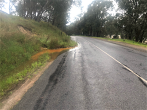
Mansfield Shire Council staff are working closely with SES to respond to flooding events as they occur. Images from the clean-up being undertaken by our crews over the last week show the following damage on roadways:
- Merton-Strathbogie Road sink hole
- Kubeils Road, Merton, wash damage
- The Sideling, Jamieson, shoulder damage
- Buttercup Road, Merrijig, road damage
- Monkey Gully Road, Mansfield, land slip onto the road
- Mitchells Road, Ancona, crossing damage
Mayor Cr James Tehan reminded drivers to take extra precautions when driving after heavy rain events.
“Council has had more than a hundred calls about obstacles on roadways in the wake of the initial rain event. I urge drivers to exercise caution when driving, especially in the immediate period after a rain event,” said Cr Tehan.
“This is a timely reminder that the Shire needs the Mansfield Emergency Services Precinct including a Resilience Centre. Extreme weather is likely to continue, and we are about to move from heavy rains into the fire season. This, coupled with the massive increase in visitation we get over summer, exacerbates the risks to our community. We are advocating strongly to ensure this is front of mind for all candidates in the lead up to the election.”
Council is working with SES to ensure the community is kept up-to-date with local information. On Facebook, follow Council @MansfieldShireCouncil and the SES Mansfield Unit @MansfieldSES.
Always have the VicEmergency app downloaded on your phone to be alerted to potential emergencies near you.


Hero Image - Monkey Gully Road, Mansfield
Image 1 - The Sideling, Jamieson
Image 2 - Mitchells Road, Ancona
Image 3 - Buttercup Road, Merrijig